Digital Twin for Built Environment
Use in all kinds of urban development and construction projects
City Planning
Manage and collaborate city plans with citizens with a 4D digital twin of a city and feedback tools
Architecture
Manage architecture in their real world location and integrate into city models. Compare architecture competition alternatives with VR and AR.
Infrastructure
Manage even large scale infrastructure projects and combine designs with survey, drone and as-built data
Transportation
Manage harbor, airport and logistics center projects by combining infrastructure, buildings, and city models
Environment
Bring landscaping and environmental planning live with AR and VR. Manage environmental effects analysis in large scales.
Energy
Manage geographically large distribution networks, windmill parks and power plants in their real world surroundings
Industry
Combine buildings, machines, processing plants and infrastructure into one digital twin of the facility
Real estate
Show apartments and housing virtually in their real location and surroundings with city model integration
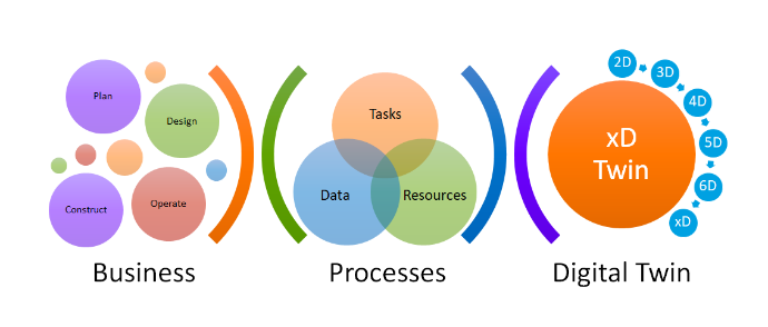
Manage projects in any life cycle phase
Project owners like cities can manage projects in all project life-cycle phases. When project owners manage digital twins it is easy to move project data from phase to another. This removes silos and ensures that project data is always safe, available and under control.
Planning
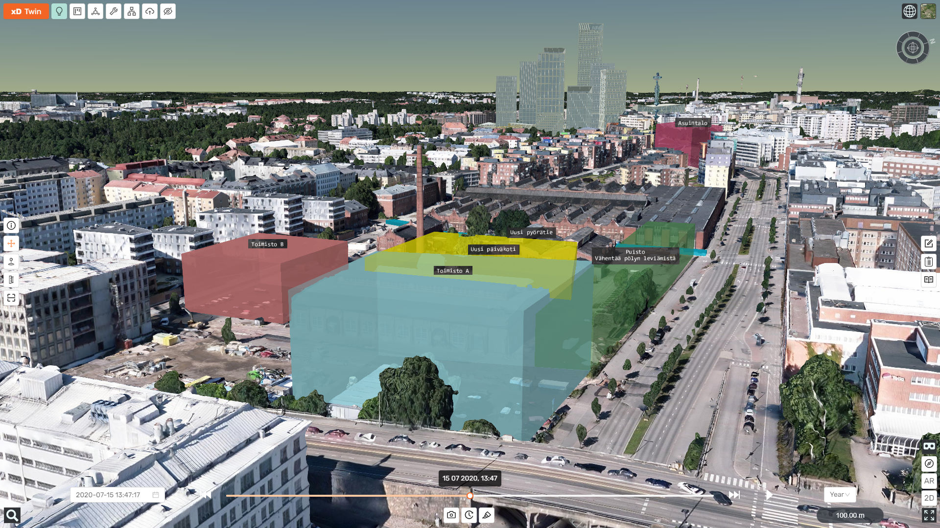
Integrate area plans and architectural models with city model to analyze how the future cityscape will look like.
Compare architectural competition alternatives in neutral and equal way in their existing surroundings.
Sketch ideas and new plans in 3D with couple of clicks.
Add time perspective (4D) to plans and designs to visualize how the city will develop in the future.
Present projects online in 3D. Immerse yourself inside your project with VR. Show your project on-site in its real context with AR.
Publish projects to the public and facilitate feedback collection from citizens.
Design
Coordinate BIM based projects on cloud.
Manage even large projects with speed and usability.
Import BIM in all disciplines including Infra and Buildings.
Combine BIM with GIS to enhance information management.
Manage tasks, issues, ideas, risks and other topics inside the model.
Automate workflows with pre-defined phases and checklists.
Improve productivity with workflow statistics.
Track project status with real-time reports and dashboards.
Publish designs to public, collect feedback and present with VR or AR on-site.
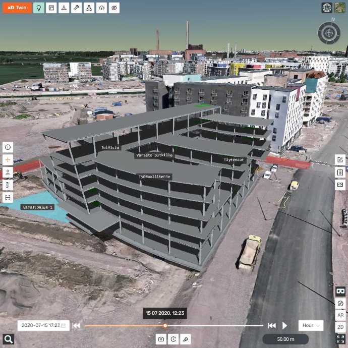
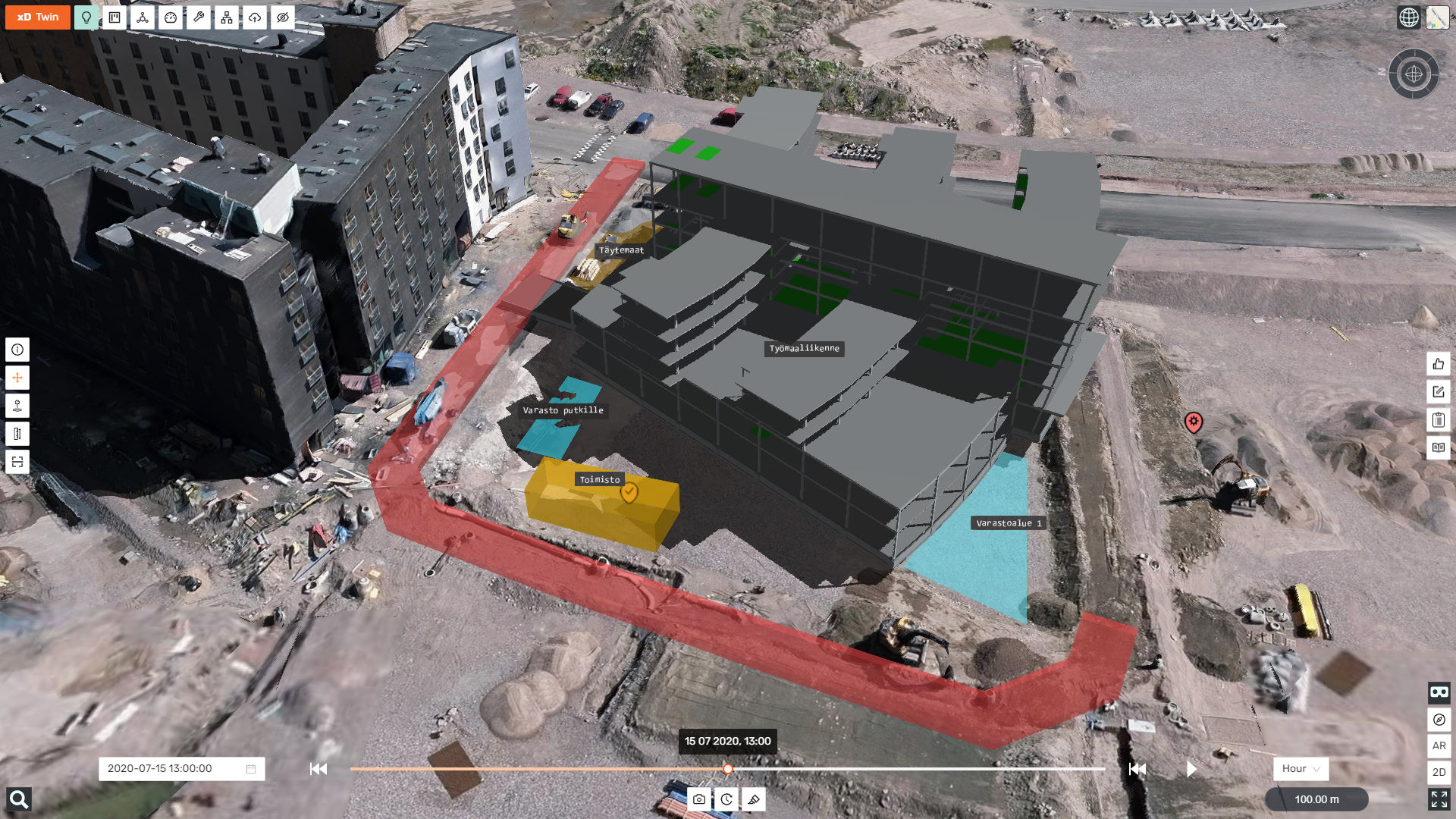
Construction
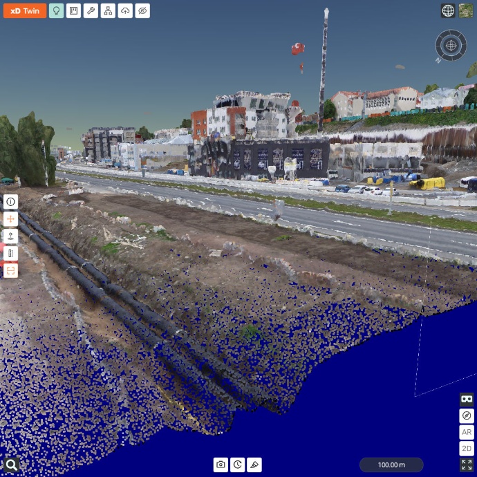
Import construction data like point clouds and drone photogrammetry models to create up-to-date situation awareness of the site.
Compare as-builts to designs and manage construction QA workflows with automation.
Save construction history as 4D model for maintenance and operations.
Plan, simulate and optimize construction production with 4D simulation.
Plan and manage site tasks and arrangements with 4D sketch tools.
Everyone can access the 4D construction
on-site with their own smart devices with automatic GPS positioning and AR, without extra costs or hardware.
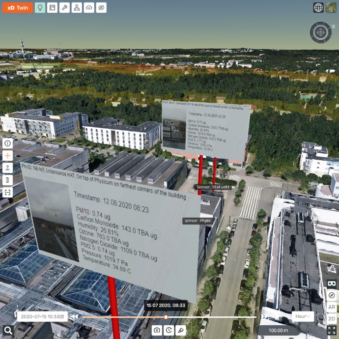
Maintenance and Operations
Keep design and construction data saved for later in future.
Integrate digital twin to asset, maintenance and operations management systems.
Use digital twin data with mobile AR user interfaces.
Link IoT sensors to assets and monitor assets during their whole life cycle.
Build up a next generation digital twin of a city by combining design BIM models, construction as-built data and city models.
BIM with Location
Manage your project in its real context and surroundings
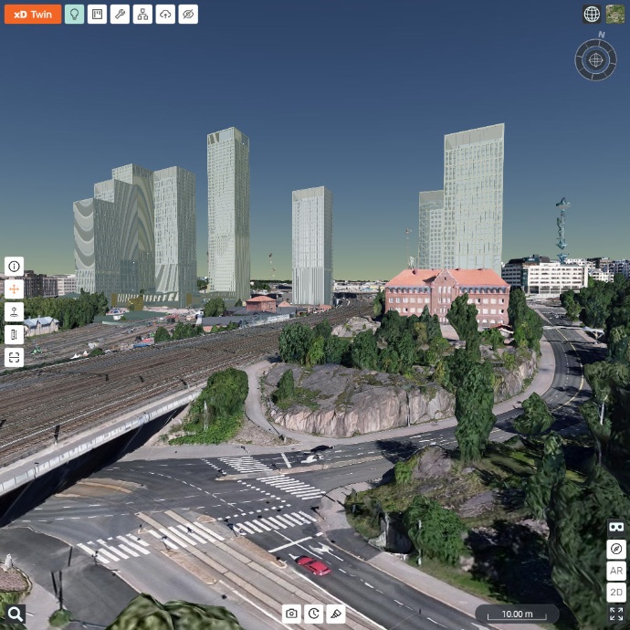
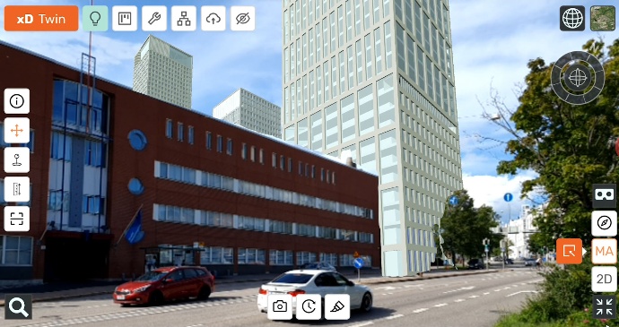
xD Twin manages project models in their real world locations. You can easily drag and drop models into their real locations. Global backgrounds like maps, aerial photos, terrain and buildings help you localize your project elements easier.
You can also integrate projects with city models which gives you the best digital understanding of how projects fit into their real surroundings.
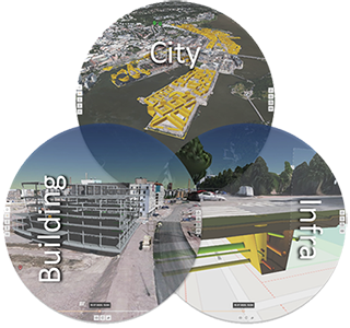
City + Buildings + Infra
Manage all disciplines as one digital twin
xD Twin is a unique digital twin solution because it integrates all project disciplines, phases and detail levels into one digital twin. With xD Twin you can manage projects that have city plans, buildings, infrastructure and transportation integrated into city models. Data can be from different project phases, detail levels and data formats.
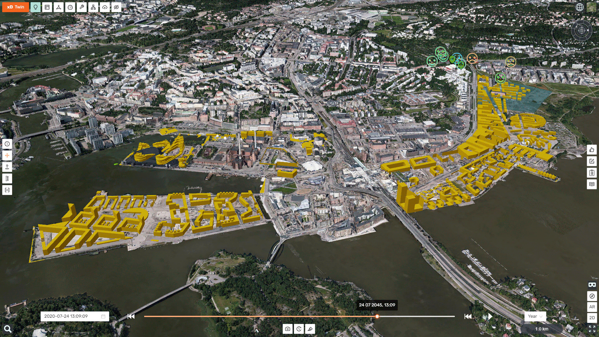
Multi-project digital twins
Project to project coordination is becoming increasingly important
Projects can share information to other projects which will help project to project coordination. You can for example share pipe networks from a street project to a building project, or you can combine one master digital twin from all sub-projects in a large area construction project .
You can even combine all city projects into one future digital twin of a city and manage whole city development as one digital twin.

BIM + GIS
Future of information management is BIM + GIS
xD Twin combines BIM and GIS into one easily manageable information model. It is rare that a project would only manage BIM data. There is a lot of data needed from GIS too, for example land usage, land ownership, property limits, nature protection, noise, air quality and many kinds of location based data and gis analysis. You can overlay this data to your project from multiple data sources with open WMS / WFS interfaces.

BIM + Time (4D)
Future of digital twins is 4D
Every project needs a schedule. xD Twin allows you to present your project schedule as a 4D simulation. This is useful for example to present how the city or city area plan will develop over time. You can also schedule design models and Sketch objects. This way you can make 4D simulations of the construction sites.
Sketch your ideas
Successful project is based on good ideas
xD Twin has simple and easy to use sketch tools that allows you to sketch your ideas directly to the models. This way you can instantly test for example how different size building volumes fit into the city scape. Or you can sketch construction site arrangements on top ot design models and site drone models.
Publish and collect feedback
Successful projects are based on open citizen collaboration
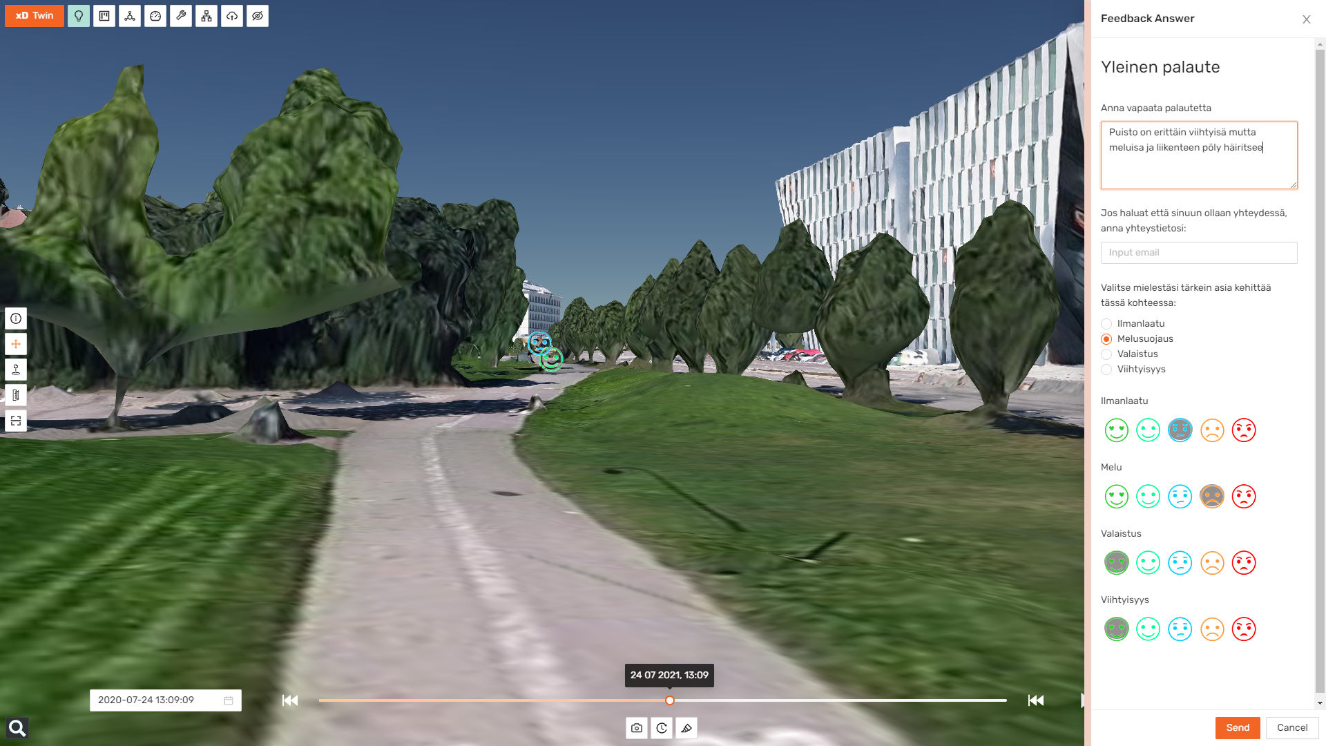
xD Twin allows you to publish your project as a public project which can be viewed by anyone without logins. This shortens the time from design to presentations and public hearings and improves transparency and collaboration with the citizens.
xD Twin has a location based feedback tool where project can customize what kind of feedback is collected and from what parts of the project. This kind of facilitated feedback can be much more valuable to the project than traditional generic feedback.
See your project On-Site
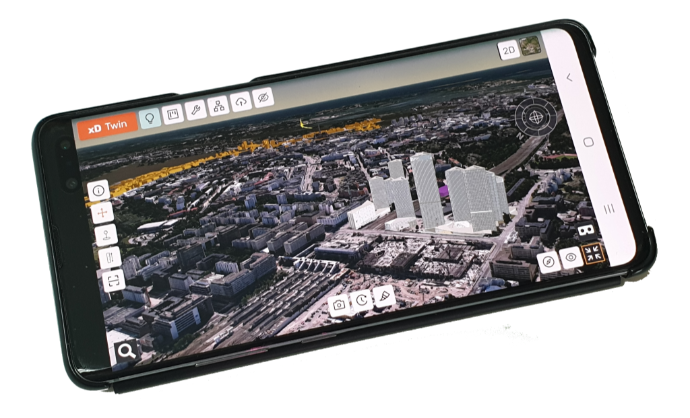
Project data can be viewed on-site with GPS positioning and compass orientation. Users can automatically zoom into their location and view data around them from the birds eye view in correct orientation.
With AR (Augmented Reality) users can view project data through the mobile device's display combined with the camera image.
-
Save time and access data on-site with automatic zoom
-
Save time and access data with simple point and click operation
Everyone on-site can use this without any extra costs. This works with any smart device and doesn't need any external hardware or services.
Easy and Fast
-
As easy to use as map apps: Everyone can learn and get benefits instantly. xD Twin works in ways most users are already used to.
-
Projects open in seconds: Access information instantly without waiting. Intelligent web3d streaming loads only what you need. This allows accessing almost unlimited size datasets.
-
Anywhere, anytime, any device: xD Twin is completely browser based and mobile friendly. Everyone can access information anywhere and anytime even with slow connections. No need to worry about app installations, privacy settings or updates. xD Twin is always up to date.
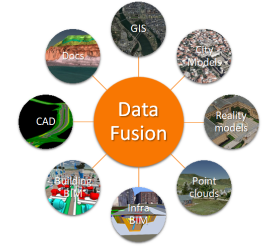
Data Fusion
Combine multiple data sources and formats in a CDE (Common Data Environment) to manage all aspects of the project as one digital twin.
-
Global maps, aerial photos, terrain and buildings
-
City models (Mesh and CityGML)
-
GIS data (WMS, WFS)
-
City planning models
-
Visualization models
-
Building BIM models: IFC
-
Infrastructure BIM models: IFC, Inframodel
-
Construction production data
-
Survey data (point clouds, lines, points)
-
Drone photogrammetry models
-
As-built data
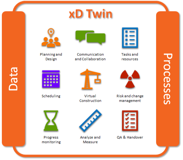
Digital Twin of Data and Processes
Projects have many processes and processes have a lot of data to manage, not to forget people who have jobs to be done. xD Twin goal is to link these into a production system that can simulate, optimize, manage and track these processes. This will result in improved production speed and cost savings. xD Twin manages this:
-
Planning, design and construction data fusion
-
Analyze and measure data to ensure quality and constructability
-
Communication and collaboration is done inside the digital twin
-
Tasks risks, ideas, notes, issues are managed inside the digital twin
-
Data is linked to tasks and workflows so they are easily available
-
Automatic reports and real-time project dashboards
-
Project can be virtually built with 4D scheduling
-
Design and as-builts can be combined for QA analysis
-
Drone and laser scan surveys create situational awareness to the site
-
Fast access to data anywhere, anytime with any device
-
Data is easily accessible on-site with GPS and AR
Virtual Construction
xD Twin goal is to make a digital twin of business processes. This means not only the digital twin of data, but also the digital twin of tasks and workflows. xD Twin links these together so that projects can be virtually constructed before actual construction. Virtual construction costs are only 0.001% of real construction costs. This allows a lot of optimization and improvements virtually before actual construction. This results in cost and time savings, sustainability and better functioning solutions.
Key features
Maps and City Models
Global maps, satellite, terrain and buildings (350M). Integrate your projects into city models.
BIM + GIS + Survey
4D Scheduling
Project Management
Check and Measure
Sketch your Ideas
Present and Share
Mobile On-Site
New generation flexibility
Based on years of experience we designed our solution from user's perspective and removed typical limitations many other solutions have.
-
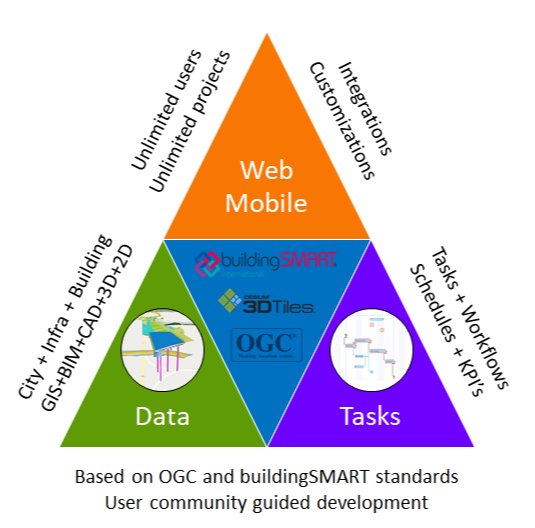
OpenBIM: Based on OGC and buildingSMART open standards. Future proof and compatible with all major design tools.
-
BIM + GIS: BIM with location. GIS information as project data. Manage geographically large projects with coordinate and elevation systems.
-
Data + Tasks: Link data to tasks so data is easily accessible when jobs needs to be done. Automate workflows to increase productivity.
-
Any device, anywhere, anytime: Fast access to data, anywhere, anytime. Massive datasets load in seconds even on mobile devices.
-
BIM On-Site: Locate data on-site fast and easily with GPS and AR. Available to everyone on-site with their own smart devices.
-
Unlimited users: Invite anyone to your project with no extra cost, bureaucracy or organization boundaries
-
Integrations and customizations: xD Twin can be integrated into organization's ecosystem and custom extensions and tools can be developed very cost efficiently by xD Visuals Oy team